Hurricane
Irma
Good Morning, as we
continue to monitor Hurricane Irma she is
still shifting towards the west towards
Charlotte and the Tennessee border. Monday
we anticipate minimal effects from Irma only
having rain and minor winds (5-10 mph). We
will continue to monitor and unless any
major track shifts this will be the last
update from Bertie County Emergency
Services.
Today
Sunny, with a
high near 78. North wind 3 to 5 mph.
Tonight
Mostly clear,
with a low around 57. Light northeast wind.
Saturday
Sunny, with a
high near 76. Northeast wind 6 to 10 mph.
Saturday
Night
Mostly clear,
with a low around 56. North wind around 8
mph.
Sunday
Mostly sunny,
with a high near 73. North wind 10 to 14
mph.
Sunday Night
Mostly
cloudy, with a low around 62.
Monday
Mostly
cloudy, with a high near 75.
Monday Night
Showers
likely after 8pm. Cloudy, with a low around
67. Chance of precipitation is 70%.
Tuesday
Showers
likely. Mostly cloudy, with a high near 79.
Chance of precipitation is 60%.
Tuesday Night
A chance of
showers before 2am. Mostly cloudy, with a
low around 67. Chance of precipitation is
30%.
Latest from NCEM below
Key Takeaways:
· Statewide impacts are still expected
despite a westward shift in the track
· General impacts from Hurricane Irma
will begin late Sunday night into Monday
morning from south to north
· Impacts from Irma will be felt far
from the center
Tropical Outlook:
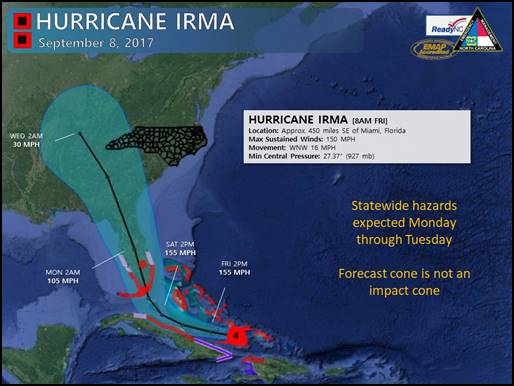
Hurricane Irma remains
a very powerful hurricane with maximum
sustained winds of 150 mph as it currently
tracks north of Cuba. The official NHC track
has shifted westward, but track errors at 4
days are almost 200 miles so it is still too
early to pinpoint exact track and potential
impacts from Irma. NC is still likely to
experience statewide impacts. The general
timeline has remained the same, with the
greatest potential impacts expected Monday
and Tuesday.
Preliminary rainfall
forecasts indicate 1 to 5” with locally
higher amounts across the mountains and SC
border with lower amounts in the northeast
counties. Inland flash flooding in low-lying
and flood prone areas remains possible,
increasing the potential for dangerous
travel conditions. Minor main stem river
flooding is also possible along with the
threat for isolated tornadoes. With the
fires in the west last year, newly
established vegetation may allow for an
increased landslide threat. With the current
track, maximum sustained winds of 25-30 mph
with gusts up to 50 mph are expected. With
these conditions, downed trees and scattered
power outages are anticipated. Minor
coastal flooding is expected across the
coastal areas and could contribute to minor
beach erosion. Small craft advisories and
rip current risks are already in effect for
New Hanover, Brunswick, Carteret, Onslow,
Dare, and Hyde counties.
Elsewhere in the
tropics, Hurricane Jose currently has
maximum sustained winds of 125 mph and is
moving toward the west-northwest near 16
mph. A west-northwestward track is expected
to continue for the next couple of days. At
this time we cannot completely rule out
potential impacts late next week, but it
appears Jose will remain to the east of
North Carolina. Hurricane Katia is not a
threat to NC as it will make landfall and
weaken over central Mexico.
Be sure to obtain your
Tropical Weather updates from trusted
sources such as the National Hurricane
Center (NHC), the National Weather Service
(NWS), and North Carolina Emergency
Management (NCEM).