Tropical
Storm Gaston and AOI#1
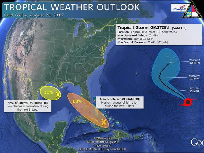
Tropical Storm Gaston remains no threat to
land as it moves across the central Atlantic
Ocean. Although the system will remain well
to the east of North Carolina, Gaston could
bring an increased rip current threat and
increased wave heights to NC beaches on
Sunday and into early next week.
The low pressure system associated with Area
of Interest #1 is located just to the north
of eastern Cuba, and it remains very weak
and disorganized. The NHC now gives this
system a low (20%) chance of formation in
the next 48 hours, and a medium (60%) chance
of formation during the next 5 days.
Conditions will become more favorable for
tropical development by the end of the
weekend and into early next week as this
system continues towards the west-northwest
and enters the Gulf of Mexico. Forecast
models continue to greatly differ in how (or
if) this system develops next week. Due to
the uncertainty, it is worth keeping an eye
on this potential system over the coming
days.
The NHC has also given a low (10%) chance of
formation to the area of disturbed weather
just east of Texas in the Gulf of Mexico.
This system poses no threat to North
Carolina, and little to no development is
expected before it reaches the coast of
Texas.
We will continue to provide regular updates
on the tropics over the weekend.
Last Updated
at 11:00AM August 26, 2016